Firebases
Fire Support Base Birmingham
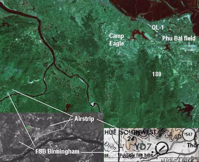
“Here is a section of 1:50,000 map overlain with recent satellite image. The numbers correspond to the previous photos. FSB Birmingham: Coordinates YD 704101; recall the rule for reading these, find the appropriate section, in this case…YD, then right and up to the most precise fraction of a square you can estimate…usually 6 digits…three in each dimension with no divider between the Right-Up sections, shown in red boxes/digits in my modified map. I don’t know all the arty units that operated here, but at least one was 1st Bn., 83rd Arty, 15th FA…they have a nice website with some pics, including the 175mm rifles that operated here…in my pics the rifles are lowered and thus not visible. Some good pictures were taken by a Steve Nirk, an engineer, I believe, and should be viewable at www.vietvet.org/bmgham.htm.
FSB Birmingham was a popular staging area for Combat Assaults, air and ground recons, LRRP insertions, and other activities because of it’s location in a valley of the “front range” of the western mountains…good access to points west but close to adequate support from Phu Bai, Camp Eagle, and if need be…DaNang.”
Hannibal, I have a number of images of B’ham from my time as a scout with D Troop, 2/17th Air Cav, 101st Abn. I’ll attach a couple and you should look around under “Places & Bases” at the excellent www.vhpamuseum.org website, at which I am a frequent contributor…make you readership aware of this site as there is a lot of related interest items for your guys there. I was based at Camp Eagle myself for a lot of ’71, and some time at Phu Bai and later, down south in III Corps.
The attached images are my own and you may use if properly credited.
Birmback.jpg : Views of North side of Birmingham from low pad, looking south. Song Huu river is on the other side. Gunjeeps on lowpad are D Troop, 2/17th Cav.
64468x.jpg: Composite satellite view of Birminham overlain on another satellite shot, with insert from 1:250,000 JOG map.
Bham81x.jpg: Contact on north side of B’ham, looking north. 81mm mortar impact smoke is visible as is small arms fire.
175impacts.jpg: 175mm rifle impacts visible in two distinct areas about 10 clicks out from B’ham…view is to the east, I think. Two aircraft can be seen in the general impact area on left side of picture.
Welcome Home!

The documents are from the USMC historical center (Spot Report) and the National Archives (the rest).
They apply to my late brother, 1lt Dennis R. Carr, B 1/327, and the bombing of Fire Support Base Birmingham on 16 March 1968. Please contact me if anyone has questions. [email protected]
All of the material is unclassified and are public records. There is no copyright.
Thanks, Tim Carr
click on images
Thanks Doug Kibbey, 11D20, D Troop, 2/17th Cav., 101 Abn. ’71, AIRBORNE!
These last two photos were taken and sent in by Wayne Smith. They were taken right before the Lam Son 719 operation, where the entire 1/327th was gathered and placed around Birmingham. I think this temporary staging area was called “Buddha” or something like that. It was sort of like a fire base surrounding Birmingham.
Martens is Lt. Martens. Was Wayne Smith’s platoon leader.
